You are at - Jotaro's Blog / AhPek Biker / Cycling Route Maps / Taiwan Cycling Route Maps
AhPek Biker - Riding Adventures
TAIWAN CYCLING ROUTE MAPS
Below are maps of routes that we cycled on a round Taiwan cycling tour. It was on of our best tours as Taiwan is full of diversity in scenery and a varied ride quality.
Click on relevant screen zoom rectangle (at the top right hand corner of each map) to go to the respective route map:
Hsinchu To Tongxiao To Taichung Taiwan Cycling Route Map (60.65km)
Cycling route: Hsinchu (新竹市)>Xiangshan Cycle Path>Haowangjiao (好望角)>Tongxiao Salt Factory (通霄精塩廠)>Tongxiao (通霄鎮)>by TRA train>Taichung (臺中).
Cycling Distance - 60.65km. Level: Medium (Hard at the uphill stretch to Haowangjiao due to strong headwinds).
The route differs from the previous day's; it's no more by the river and yet gets more interesting. It will take us through a couple of nice bike paths, up to a viewpoint with super strong winds and to a salt factory too. We are still on Taiwan's National Cycling Route #1.
_________________________________________________________________________
Exploring Hualien Taiwan Cycling Route Map (30.22km)
Cylcling Sun Moon Lake Taiwan Cycling Route Map (31.94km)
Sun Moon Lake To Tainan Taiwan Cycling Route Map (31.94km)
_________________________________________________________________________
Exploring Taichung Taiwan Cycling Route Map
Tainan To Kaohsiung Taiwan Cycling Route Map (50.37km)
_________________________________________________________________________
Exploring Hualien Taiwan Cycling Route Map (30.22km)
Route: Chantai Hotel (阡台大飯店)>Zhongshan Wet Market (中山市場)>Yuanyuan Temple (淵源堂)>Shen An Temple (花蓮勝安宮)>Cinshui River Bike Bath>Nanbin Park (南濱公園)>Pacific 3D Landscape Park (太平洋3D地景公園)>Beibin Park (北濱公園)>Meilun Coast Park (美崙濱海公園)>Hualien Port Bridge (花蓮港景觀橋)>48 Highland (四八高地)>Chisingtan (七星潭)>Chantai Hotel (阡台大飯店).
Cycling Distance: 30.22 km. | Level: Medium
The route starts of with visits to the local market, a couple of temples and then head down a cycling path along the Ji'an River (吉安河). It continues along the Pacific coast where mighty waves came crashing onto the beaches on one side and beautifully landscaped parks on the other. Onwards, a short stretch goes through the 48 Highland (四八高地) where there are panoramic views of the Chisingtan Crescent Beach, a bit of carrying of bicycles is required as this stretch is a walking trail with steps.
(.... click here to view Ride Blog)
Hualien To Taroko Taiwan Cycling Route Map (30.34km)
(.... click here to view Ride Blog)
_________________________________________________________________________
Hualien To Taroko Taiwan Cycling Route Map (30.34km)
Day 17 Route: Hualien (中山市場)>by TRA train>Xincheng Station (新城車站)>Hung Ying Hotel (太魯閣紅瑛民宿)>Arch of Taroko (太魯閣牌樓)>Zhongheng Tunnel (橫開工紀念碑)>Jiuqudong Tunnels (九匝隧道>Taroko Visitor Center (太魯閣遊客中心)>Hung Ying Hotel.
Cycling Distance: 13.94 km. Train Ride Distance: 16.40 km. Total Distance: 30.34 km.
Level: Easy/Medim
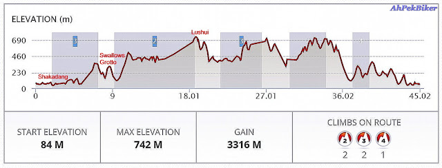
The route is one of a train ride from Hualien to Xincheng (新城鄉) and from there cycle to the Taroko National Park Visitor Center and at the roads around the centre. The next day we took the HopOn/HopOff Taroko shuttle bus to go further into the Taroko National Park and visit the Shakadang Trail, the Swallows' Grotto Yanzikou Trail, the Lushui Trail, the Lushui Visitor Centre, and Tianxang Village. The round trip bus journey is about thirty-four kilometers, it's doable on bicycles; one just need to have strong legs and be alert at the many meandering turns.

This is the elevation of the round-trip route that starts from near the Arch of Taroko up to Lushui Trail. The total distance of forty-five kilometres includes hiking/walking within the Shakadang Trail, the Swallows' Grotto Yanzikou Trail, and the Lushui Trail,
Those with strong legs, Go For It!
Those with strong legs, Go For It!
_________________________________________________________________________
Kaohsiung To Xiaoliuqiu Island Taiwan Cycling Route Map (21.07km)
Route: Kaohsiung (高雄市)> by Kaohsiung Metro (高雄捷運)>Xiaogang>Xiaogang Bike Path>Shuangyuan Bridge (雙園大橋)>Donggang Bridge (东港大桥)>Dongganghedi Park (東港河堤公園)>Dongliu Ferry Terminal (東港渡船碼頭)>by Tungliu Ferry>Xiaoliuqiu (小琉球) (Bai Sha Wei Ferry Pier,白沙尾渡船碼頭).
Cycling Distance - 21.07km. Level: Easy
The route includes a train ride from Kaohsiung to Xiaogang, The cycling is from there to Donggang (東港鎮) for a ferry crossing from the Dongliu Ferry Terminal over to Xiaoliuqiu Island. Part of the cycling route is along the Xiaogang Bike Path and the promenade at Dongganghedi Park. At Donggang is a must view sexy red bridge.
_________________________________________________________________________
Exploring Kenting Taiwan Cycling Route Map (69.29km)
Kenting To Taitung Taiwan Cycling Route Map (36.32km)
Exploring Kenting Taiwan Cycling Route Map (69.29km)
Route: Kenting (墾丁)>Southernmost Tip of Taiwan (臺灣最南點碑)> Fongchueisha (風吹砂)>Manzhou (滿州)>Hengchun (恆春)>Maobitou Park (貓鼻頭公園)>Taipower Southern Exhibition Centre (核能展示館)>Kenting (墾丁).
Distance - 69.29 km. Level: Hard (due slopes & strong headwind)
The route includes is a loop around the narrow southern tip of Taiwan from Kenting to the south-eastern tip then upwards into the hinterland before proceeding to the south-western tip and returning back to Kenting.
(.... click here to view Ride Blog)
_________________________________________________________________________
_________________________________________________________________________
Kenting To Taitung Taiwan Cycling Route Map (36.32km)
Route: Kenting (墾丁)>by van>Fangliao (枋寮鄉)>by TRA train>Dawu (大武鄉)>Taimali (太麻里鄉)>by TRA train>Taitung (臺東市).
Cycling Distance=36.32 km Total Distance=159.42 (inclg. van & train journey)
Level: Medium Hard (Undulating slopes and strong headwind on the eastern coast).
The route includes riding a van (from Kenting to Fangliao) and a couple of train sections (from Fangliao to Dawu & from Taimali to Taitung), but it is doable fully on bicycles but would recommend doing it over two days as the segment from Fangliao to Dawu cuts through steep hills. From Dawu to Taimali, the route runs along undulating terrain with some short stretches of steep slope.
_________________________________________________________________________
Cycling route: Shuishe Pier (水社碼頭)>Wenwu Temple (文武廟)>Chun-hua Restaurant (尚好小吃部)>Xuanzang Temple (玄奘寺)>Yuchi Township (魚池鄉>Crescent Bay Monuement (南投)>Scenic Observation Deck Scenic (向山懸臂式觀景台)>Shuishe Dam (水社壩)>Shuishe Pier.
Cycling Distance - 31.94 km. Level: Medium (except for one hard hilly stretch that veered away from the lake at Yuchi Township (魚池鄉)).
The route goes around Sun Moon Lake with a section veering inwards at Yuchi Township, it is mostly a shady route that passes through a couple of temples and several scenic viewpoints. Sections of it are on lake-side bike paths while those near the temples and away from the lake are quite steep with sharp bends including hair-pin turns.
(Note: zoom out to view location of the Nantou's Gamcheng Station and our breakfast place, the 阿文小麵店 shop, both in Taichung (臺中).
_________________________________________________________________________
Sun Moon Lake To Tainan Taiwan Cycling Route Map (31.94km)
Route: Sun Moon Lake (Shuishe Pier) (水社碼頭)>by van>Shuili (水里鄉)>by TRA train>Ershui (二水鄉)>by TRA train>Dounan (斗南鎮)>Minxiong (民雄鄉)>Chiayi Tropic of Cancer Monument (北回歸線太陽館) >Shuishang (南投)>by TRA train>Tainan (臺南市).
Cycling Distance - 33.12 km. Level: Easy
From Sun Moon Lake it's by van to Shuili to catch a train to Ershui, and then onto a connecting train to Dounan. We cycled from there to visit the Tropic of Cancer Monument and then onwards to Shuishang where we boarded a train to Tainan.
Cycling Distance - 33.12 km. Level: Easy
From Sun Moon Lake it's by van to Shuili to catch a train to Ershui, and then onto a connecting train to Dounan. We cycled from there to visit the Tropic of Cancer Monument and then onwards to Shuishang where we boarded a train to Tainan.
Exploring Taichung Taiwan Cycling Route Map
Cycling route: Taichung Chance Hotel (巧合大飯店)>Minsheng Rice Cakes (嘉義民生米糕)>Rainbow Village (彩虹眷村)>HSR Taichung Station>by cab>Wufeng Lin Garden (霧峰林家宅園)>Taichung Park (臺中公園)>Yizhong Night Market (一中街夜市)>Taichung Chance Hotel.
Cycling Distance - 35.99 km. Level: Easy
This is any easy route to take a short tour of Taichung City several places of interests. There is a break in the cycling journey when we took a van-taxi from the HSR (High Speed Rail) Station to the Wufeng Lin Family Garden.
_________________________________________________________________________
This is any easy route to take a short tour of Taichung City several places of interests. There is a break in the cycling journey when we took a van-taxi from the HSR (High Speed Rail) Station to the Wufeng Lin Family Garden.
Tainan To Kaohsiung Taiwan Cycling Route Map (50.37km)
Route: Tainan (臺南市)>Tainan Metropolitan Park (台南市政府觀光旅遊局)>Chimei Museum (奇美博物館)>Yan Tian (鹽田)>Wuli Bridge (五里林橋)>Kaohsiung Metropolitan Park (高雄都會公園)>by Kaohsiung Metro (高雄捷運)>Kaohsiung (高雄市).
Cycling Distance - 50.37 km. Level: Medium
The route runs along secondary road, and also partly on the Gangshan-Ciaotuo Cycle Path running along the Agongdian River (阿公店溪) at Gangshan District. Destination enroute is the Yan Tian Painted Village (鹽田社區彩繪巷).
Exploring Taipei Taiwan Cycling Route Map
Route - Walking Around Taipei
Not applicable as walking around.
This map covers several days of our Taiwan tour and includes cycling in Taipei and Tiamsui, a lovely outskirt district in the north-east. Completion pending other days route in Taipei.
_________________________________________________________________________
Cycling Taipei Tamsui River Bikeway Taiwan Cycling Route Map (14.29km)
Taipei To Hsinchu Taiwan Cycling Route Map (44.29km)
Cycling route: Ximending (Taipei)>Dadaocheng Park>Dadaocheng Wharf (大稻埕碼頭)>Machangting Memorial Park>Huazhong Bridge (恐龍園区)>Jiangzicuijingguan Park>Fuzhouzujie Biking Station>Sanxia Old Street>Yingge Railway Station>by TRA train>Hsinchu Railway Station.
Taitung To Yuli Taiwan Cycling Route Map (41.12km)
_________________________________________________________________________
Taroko To Taiwan Taiwan Cycling Route Map (194.80km)
_________________________________________________________________________
Xiaoliuqiu Island To Donggang To Kenting Taiwan Cycling Route Map (65.04km)
MORE TAIWAN CYCLING ROUTES COMING!
STAY TUNED!!!
_________________________________________________________________________
Cycling Taipei Tamsui River Bikeway Taiwan Cycling Route Map (14.29km)
Cycling Route: Ximending (西門町)>Taipei Cinema Park (臺北市電影主題公園)>Dadaocheng Pier Plaza (大稻埕碼頭廣場)>Machangting Memorial Park (馬場町紀念公園)>Ximending.
Cycle Distance = 14.29km | Level: Easy
This is a quick loop along the Tamsui River Bikeway. Starting from Ximending via the Taipei Cinema Park to start riding along the river at Dadaocheng Wharf down to M? and then looping back along city roads.
_________________________________________________________________________
Taipei To Hsinchu Taiwan Cycling Route Map (44.29km)
Distance: 44.29 km. Level: Medium
Taipei To Tamsui Taiwan Cycling Route Map (56.90km)
This interesting route starts from the busy streets of Taipei and then goes onto the dedicated cycling paths along Tamsui River, Dahan River and Xindian River. The dedicate path exits just before Sanxia and continues along shared bike lanes. Most of the paths were on Taiwan National Cycling Route #1.
_________________________________________________________________________
Route: Ximending (西門町)>Ximen Station (西門站)>by MRT>Zhongshang Station (中山站)>by MRT>Shilin Station (士林站)>National Palace Museum>Shilin Station (士林站)>by MRT>Tamsui Station (淡水站)>Tamsui Customs Wharf (淡水海關碼頭)>Tamsui Station (淡水站)>by MRT>Zhongshang Station (中山站)>by MRT>Ximen Station (西門站)>Ximending (西門町).
Cycle Distance = 11.97km | Train Distance =44.93km | Total Distance = 56.90km
Level: Easy
This is a route with minimum cycling and more train rides so that there will be more time at the National Palace Museum and Tamsui.
_________________________________________________________________________
Taitung To Yuli Taiwan Cycling Route Map (41.12km)
Route: Taitung (臺東市)>by TRA train>Luye (鹿野鄉)>Guanshan (關山鎮)>Chishang (池上鄉)>by TRA train>Yuli (玉里鎮).
Cycling Distance: 38.03 km Total Distance: 78.33km (inclg. two train journeys)
Level: Easy (Medium if doing the whole route by cycling).
The route heads into the interior scenic Huadong Valley (花東縱谷, East Rift Valley) and includes riding a couple of train rides (from Taitung to Luye & from Chishang to Yuli), but it is doable fully on bicycles.
Taroko To Taiwan Taiwan Cycling Route Map (194.80km)
Route: Hung Ying Hotel (太魯閣紅瑛民宿)>Xincheng Station (新城車站)>by TRA train>Songshan Station (松山火車站)>Keelung River Path>Tamsui River Bikeway>Dalongdong Baoan Temple (大龍峒保安宮)>Ximending (西門町) (Taipei).
Cycle Distance = 22.28km | Train Distance = 172km | Total Distance = 194.58km.
Level: Easy
The route is one of a train ride from Xincheng (新城鄉) to the Songshan Station and from there cycle to Ximending in (Taipei) via the Keelung & Tamsui River bike paths. It's an interesting cycling route with many parks along the river bike-ways.
_________________________________________________________________________
Exploring Xiaoliuqiu Island Taiwan Cycling Route Map (18.09km)
Route: Greenia Minsu>Biyun Temple (碧雲寺)>Tiannan Fu An Temple (天南福安宫)>Haizikou Viewpoint (海子口)>Dafu Fishing Harbor (大福漁港)>Xiaoliuqiu Sunset Pavilion (落日亭)>Xiaoliuqiu Lingshan Temple (小琉球靈山寺)>Vase Rock (花瓶岩)>Greenia Minsu.
Cycling Distance - 18.09 km. Level: Medium
A route that goes to a couple of temples, harbors, some significant rocks and a beautiful sunset.
_________________________________________________________________________
Xiaoliuqiu Island To Donggang To Kenting Taiwan Cycling Route Map (65.04km)
Route: Xiaoliuqiu (小琉球) (Bai Sha Wei Ferry Pier,白沙尾渡船碼頭)>by Tungliu Ferry>Dongliu Ferry Terminal (東港渡船碼頭)>Nanzhou (南州鄉)>by TRA train>Fangliao (枋寮鄉)>Fangshan (枋山鄉)>Checheng (車城鄉)>Kenting (墾丁).
The route includes a ferry crossing from Xiaoliuqiu and a train ride from Nanzhou to Fangliao. Cycling was on the stretches from Donggang to Nanzhou, and from Fangliao to Kenting.
(.... click here to view the Ride Blog)
Yuli To Hualien Taiwan Cycling Route Map (70.24km)
_________________________________________________________________________
Yuli To Hualien Taiwan Cycling Route Map (70.24km)
Route: Yuli (玉里鎮)>Tectonic Plate Marker (欧亚板块与菲律宾海板块交界处)>Donglitiemayi Station (東里鐵馬驛站)>Ruisui Tropic of Cancer Marker (北回歸線標誌公園)>Danongdafu (大農大富平地森林園區)>Guangfu (光復鄉)>by TRA train>Hualien (花蓮市).
Cycling Distance: 70.24 km. Train Ride Distance: 43.20 km. Total Distance: 113.44 km.
Level: Hard.
The route heads goes through the interior plains of the scenic Huadong Valley (花東縱谷, East Rift Valley) and then goes uphill before Ruisui (瑞穗鄉). It includes a train rides (from Guangfu (光復鄉) to Hualien (花蓮市). It is doable fully on bicycles but then there will be less time to enjoy several destinations en-route.
_________________________________________________________________________
MORE TAIWAN CYCLING ROUTES COMING!
STAY TUNED!!!
_________________________________________________________________________
Related Blogs :


You are at - Jotaro's Blog / AhPek Biker / Cycling Route Maps / Taiwan Cycling Route Maps
If you like this, view my other blogs at Jotaro's Blog
(comments most welcomed below. if you like this pls share via facebook or twitter)
No comments:
Post a Comment