You are at - Jotaro's Blog / AhPek Biker / Cycling Philippines Batanes / Day 2-2 : North Batan Beauties | Jump to Day 1 / 2-1 / 3-1 / 3-2 / 4 / 5-1 / 5-2 / 6 / 7-1.1 / 7-1.2 / 7-2 / 8
AhPek Biker - Riding Adventures
Cycling Philippines Batanes Day 2-2 : North Batan Beauties
 Batanes Islands - Day 2-2 : 15th March 2015
Route : North Batan Island - Marfel's Lodge>Basco Lighthouse>Vayang Rolling Hills>Japanese Tunnels>Valugan Boulder Beach>Marfel's Lodge
The ride will be a short stint around the northern part of Batan Island, a sort of introduction to the beauty of the Batanes and local life in Basco, the provincial capital. We will ride to see the attractions at the hills and the beaches.

Trio Ride : North Batan Island - Marfel's Lodge>Basco Lighthouse>Vayang Rolling Hills>Japanese Tunnels>Valugan Boulder Beach>Marfel's Lodge
Distance: 15.33 km.
Time : 9:00am to 5:20pm
Time Taken : 8 hrs. 20 minutes (it was a leisurely ride with many long stops to enjoy the place, have brunch and take photos).
Route Recommendations :
1. For those from right-hand drive countries, take note that the Batanes are left-hand drive. Do keep right when you ride otherwise you will be cycling on the wrong side. The cooling wind may lull one into thinking that one won't get sunburnt.
2. Much of Batan Island does not have trees to provide shade, do cover up or use sun-block lotions.
3. Except for the town areas and coastal road, most of Batan is hilly.
4. Parts of the route are on off-road paths, allow for tires to take these road conditions.
Time : 9:00am to 5:20pm
Time Taken : 8 hrs. 20 minutes (it was a leisurely ride with many long stops to enjoy the place, have brunch and take photos).
This is page 3 of a 13-page blog, Click Here To Go To Title Page.
Route Recommendations :
1. For those from right-hand drive countries, take note that the Batanes are left-hand drive. Do keep right when you ride otherwise you will be cycling on the wrong side. The cooling wind may lull one into thinking that one won't get sunburnt.
2. Much of Batan Island does not have trees to provide shade, do cover up or use sun-block lotions.
3. Except for the town areas and coastal road, most of Batan is hilly.
4. Parts of the route are on off-road paths, allow for tires to take these road conditions.
5. Along the route were several points of interest that should not be missed, which includes:
- Santo Domingo Church - Cathedral of the Immaculate Conception (GPS: 20.45084, 121.96959),
- Basco Lighthouse (GPS: 20.45153, 121.96415),
- Vayang Rolling Hills (GPS: 20.46558, 121.96476),
- Basco Lighthouse (GPS: 20.45153, 121.96415),
- Vayang Rolling Hills (GPS: 20.46558, 121.96476),
- Valungan Boulder Beach (GPS: 20.43888, 121.98805),
- The old Spanish era stone houses with thatch roofs.
- stopping to interact with the locals, they are really warm and helpful.
- stopping to interact with the locals, they are really warm and helpful.
- Lunch was at the canteen of the Saint Dominic College of Batanes (GPS: 20.45071, 121.96894),
- Dinner was at Pension Ivatan Batanes (GPS: 20.44798, 121.9723).
6. We stayed at Marfel’s Lodge Main (then just know as Marfel's Lodge) (GPS: 20.44871, 121.97381), pre-booked via email (marfellodge@gmail.com).
__________________________________________________________________________________
PRELUDE

In Day 2 Part 1, we had arrived in Basco, Batanes and had almost immediately rode out to have a look and get acquainted with the town and its people. We liked the rustic town and its warm, friendly people.
Now it's time to cycle further and higher, up some hills and down to the beach to see the sights that North Batan is renown for.
THE RIDE
Route : North Batan Island - Marfel's Lodge>Basco Lighthouse>Vayang Rolling Hills>Japanese Tunnels>Valugan Boulder Beach>Marfel's Lodge
The ride will be a short stint around the northern part of Batan Island, a sort of introduction to the beauty of the Batanes and local life in Basco, the provincial capital. We will ride to see the attractions at the hills and the beaches.
(Click here for route map link)
___________________________________________________________________________________
BASCO LIGHTHOUSE
 The initial part of the route up to the Naidi Hills was a gentle slope shaded with trees on both sides but the road became steeper. The steeper slopes coupled with stones that now surfaced the road made it harder to ride on. It was only the thought of reaching the lighthouse and seeing the surrounding scenery that egged us on.
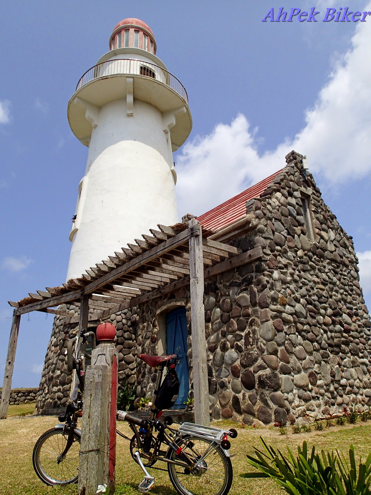 The Basco Lighthouse (also known as the Naidi Lighthouse) was a Spartan one with a stone house at the bottom, it's simplicity was its beauty. It was a rewarding view worth the climb up.
 Over at another side, Siew Yung was posing for photos to be taken by Ong.
Yes, we were thoroughly enjoying ourselves - the view, the cool strong wind and even the smell in the air; taking deep breathes as we took in the scenery.
 The little stone-house at the bottom has a souvenir shop manned by a pretty Filipina girl and next to it are stairs that lead up to the top of the lighthouse. I would encourage visitors to the place to go up; the view of Batan Island from the top is spectacular!
Mount Iraya lies on the left, (almost always having clouds covering its top) and to the right the island stretches to the away.
 Contented and light-hearted, Ong and me rode down the slopes while Siew Yung was still happily enjoying the lighthouse.
Partway down I saw this man carrying something odd. As we got closer... Hey! Those are octopuses, are they a delicacy here?
 At the bottom, a pause at the Basco Cemetery for a different view of the lighthouse.
And then we crossed over to a pizza joint to have drinks while waiting for Siew Yung to come down.
We waited, and waited.... and waited!
After almost half an hour there was still no sign of her!
Getting worried, I rode back up to look for her while Ong waited.
Up at the light house... no sign of her....Hmmm..... I hoped that she had not been captivated or held captive by a handsome Filipino hunk. As I rode back downwards, I noticed this other road on the left..."Hey, isn't that the road that lead up to the rolling hills?" and rode up there to search.
___________________________________________________________________________________
VAYANG ROLLING HILLS
 The road up to the rolling hills is not long (about 3km) but it has many slopes that goes up and down, and up and down. It was a tough climb cycling up there, but I just pedalled on anxious to find my friend.
 Up at Vayang, I saw Siew Yung; just she and her bicycle - no Filipino hunk around.
She was thoroughly enjoying the place, a place of gentle rolling hills covered by light green grass with hardly any trees around.
Many hills at these islands have few trees giving them that rounded green look. This is because at these former volcano land, most places has only a thin layer of top soil covering the lava rocks, these are not deep enough for trees to take root.
 Siew Yung was enjoying the place... and soon so was I...
 ... and so was Goofy, my bike.
This place has both the sea with it's mighty cliffs; and beyond that hills, just gently rolling away.
 Like this cow, I could just lie down for hours and bask in this place; taking in the majestic sceneries as the cool air blew, rustling through the grass...
Then something JOLTED my mind...
ONG!
So enraptured by this place, I had forgotten about him. I quickly phoned him, told him that I have found Siew Yung and asked him to come up *smirks sheepishly*.
___________________________________________________________________________________
DIPNAYSUPUAN JAPANESE TUNNELS
 After getting engrossed at the rolling hills for almost ninety minutes; it's time to move on, it's time to go over to the other side of the island to view other sights there. Basco, located at north Batan, is at the neck of the island so we did not have to cycle far; we only had to cycle up and down several steep slopes.... *Pant!....pant...*
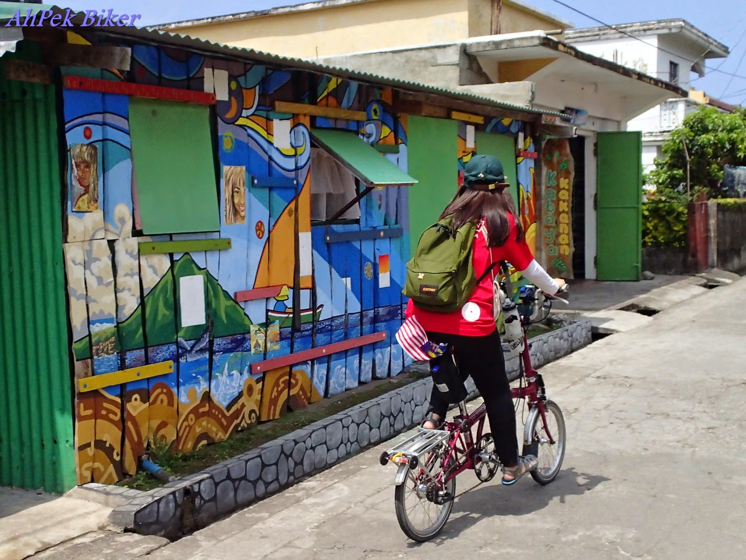
We did however pass by Basco town again and I took the opportunity to observe life there again. This lady owns a grocery store, selling some of the islands' favourites - dried Dibang (Flying Fish), garlic and onions... AND the renown Dorado fish (the ones hanging on the right of the above photo). Dorado means "gold" in Spanish; and the fish is so named as they scales exude a golden sheen when they are swimming in the sea. But it is the pickled and dried Dorado that is a much priced delicacy in the Philippines, selling for up to 1,000 PHP per kg in the major cities. Over at these islands, it sells for about the third of that price.
 Met this two young girls cycling in the streets and they were most happy to pose for us.
That's the thing we like about Batanes too, there is zero crime rate (as claimed by the islanders). The people here really practice the adage "Honesty Is The Best Policy". In fact there is a coffee-shop called "Honesty Cafe" in Ivana where no one man the shop and patrons just record down what they drank/ate and what souvenirs they bought, and plonk their payment into a basket.
That's why these two girls feel safe cycling around on their own; like many locals they have probably been brought up without an inkling on the concept of dishonesty or perhaps any of the other vices.
 Up at Tukon Hills, where the tunnels are located, we saw this man in a make-shift hut, in our ignorance we thought that he was one of the locals. He is actually Mr. Bata the caretaker, one appointed by Basco's Tourism Office and we should have spoken to him for more info on these tunnels. If you do see him, kindly extend our apologies.
The Dipnaysupuan Japanese Tunnels were some of the many tunnels dug into the Batanes. On 8th December the Japanese task force departed from Formosa, landed and occupied Batan Island. The island is one of the earliest taken by the Japanese in the Philippines and they occupied it for the duration of World War 2. The Japanese with the use of forced local labour, dug tunnels into the islands to fortify them.
 Used as a shelter/small fortress, the tunnels are accessed through small manholes; two of these lead from Tukon while another three lead from Taytay. From the shape of the entrance manhole, I would imagine that they were also used as bunker openings where canons or machine guns were placed.
 The tunnels are a series of interlink ones leading to bunkers were the Japanese soldiers can hide out for months. The first few metres near the entrance are concrete lined but further in it is just earth lined, the volcanic soil/gravel combination made this tunnels stable without the need of any shoring.
Small vertical ventilation vents lead upwards to the surface of the hills to facilitate air circulation in the tunnels.
 Do bring flash-lights as further into the tunnels it's complete darkness. These tunnels are fairly tall (about 1.5 metres) but at certain points it gets lower (probably because of bedrock), so even with flash-lights walk with care and don't just look down at the floor, take glances up too. I know as I bumped my head into a drop in the roof...."Ouch!"
I am always weary of eerie places in where people may have died; I kept glancing to the right, left, top, bottom, and hardly daring to glance behind. Siew Yung said not to worry she will take care of me if any ghosts appear - see, she's the brave one, I am the chicken afraid of ghosts.
 Steps lead down, some say two hundred feet down, to bunkers below. Shall we go down?
"Okay, enough of this. Let's go out already." I remarked to SY.
VAMOOSE!
___________________________________________________________________________________
VALUGAN BOULDER BEACH
Leaving the tunnels, we cycled upwards a bit, intending to go see the best resort in Batanes, the Fundacion Pacita Nature Lodge. This resort was formerly the home of artist Pacita Abad and has now been refurbished into a boutique hotel.
Some locals informed us that the place was closed for renovations, so we decided not to ride over. But probably it was just an excuse for us; the hotel seemed a distance away and the road leading there seems treacherously steep - and we had had only a few hours sleep this morning.
 Happily we went whooshing down the slopes, down towards shadier roads on the way over to Valugan Boulder Beach.
Somewhere along the "whooshing", a strong gust of wind came and blew Ong's hat over to an open field and down a slope. We stopped and looked and looked but could not find it. Poor Ong, that loyal hat had been accompanying him on his travels for a long time and had served him well.
 At Valugan, Ong was in his element, it was time for some serious photography. Setting up his tripod, with his back-pack hanging as a counterweight against the strong wind. There he was right at the water's edge, amid the roaring waves and undeterred by the loud breakers crashing onto the the rocky edge; waiting for opportune moments to capture good photos . His lost hat, for the moment, a thing of the past.
One of the rewards of Ong's patience, a misty, surreal look of the Valugan Boulder Beach.
Yup! That's me and Goofy, my Brompton. Goofy has gone many places with me, most times it carries me, sometimes I carry it. The way I see it, we should enjoy ourselves together.
The dark blue sea merging to a light blue horizon, the waves with slow staccato roars and a strong wind whispering in the air - the picture is just perfect.
 I took a step back to ponder on this melding song of colours and sound, admiring in awe at Mother Nature's creativity.
These boulders were hot rocks spewed out onto the beach by Mount Iraya eons ago when it was an active volcano. The waves have through the ages slowly eroded them into the round boulders we see today.
___________________________________________________________________________________
 Dinner was at Pensioner Ivatan, the food was mediocre and the service was very slow.
Fortunately there was this ugly fellow, a coconut crab, to keep us occupied for a while; we were tempted to order this crab for part of our dinner, their pricing of almost 2,000PHP was an expensive deterrent. (On another day, we did get to savour this delicacy.)
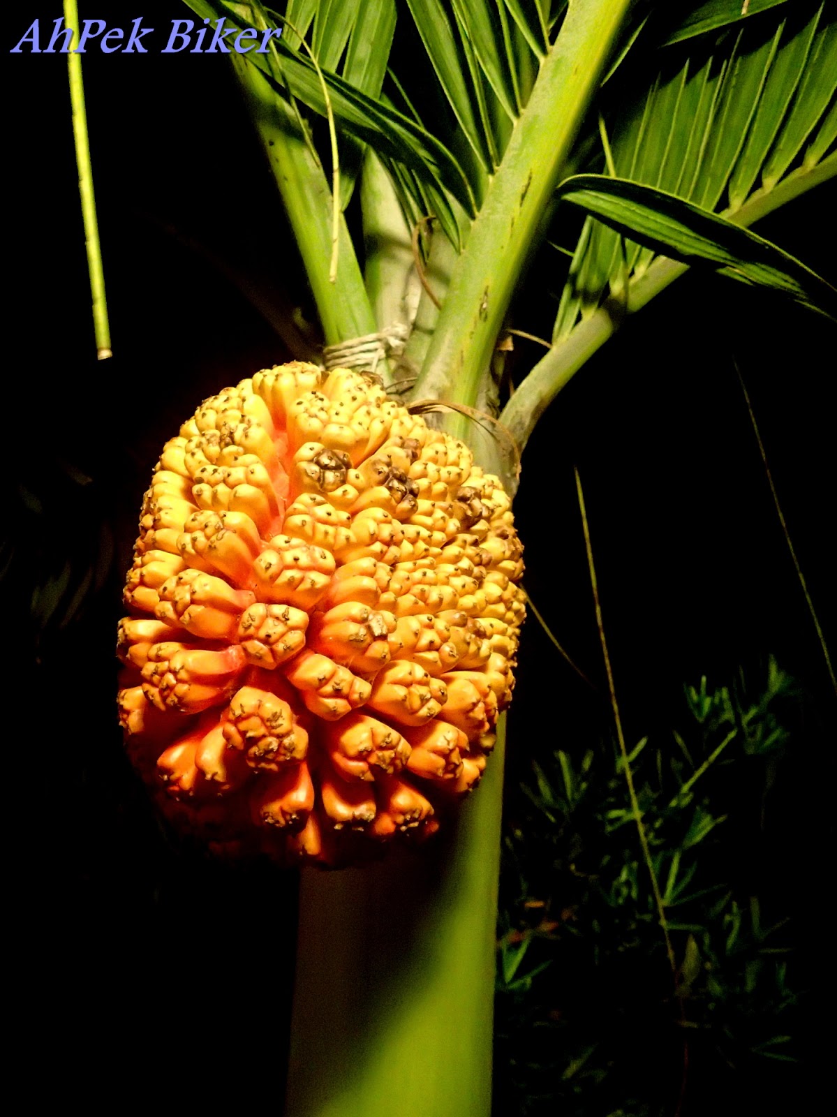 Surrounding the outside dining area were these palms with bright orange fruits (Pandanus Tectorius). These Screw Pines are one of the coconut crabs diet; they were tempting and Siew Yung plucked one to try and stated that they were softly crunchy and sweet.
"Hey, are those edible by humans?" I enquired.
Fortunately, she did not develop any stomach upset or come out with any weird orange spotty rashes. They were edible after all.
 Magandang Gabi....
(that's Good Night in Filipino)
(To see more photos for the day, Click here.)
___________________________________________________________________________________
___________________________________________________________________________________
BASCO LIGHTHOUSE


Yes, we were thoroughly enjoying ourselves - the view, the cool strong wind and even the smell in the air; taking deep breathes as we took in the scenery.

Mount Iraya lies on the left, (almost always having clouds covering its top) and to the right the island stretches to the away.

Partway down I saw this man carrying something odd. As we got closer... Hey! Those are octopuses, are they a delicacy here?

And then we crossed over to a pizza joint to have drinks while waiting for Siew Yung to come down.
We waited, and waited.... and waited!
After almost half an hour there was still no sign of her!
Getting worried, I rode back up to look for her while Ong waited.
Up at the light house... no sign of her....Hmmm..... I hoped that she had not been captivated or held captive by a handsome Filipino hunk. As I rode back downwards, I noticed this other road on the left..."Hey, isn't that the road that lead up to the rolling hills?" and rode up there to search.
___________________________________________________________________________________
VAYANG ROLLING HILLS


She was thoroughly enjoying the place, a place of gentle rolling hills covered by light green grass with hardly any trees around.
Many hills at these islands have few trees giving them that rounded green look. This is because at these former volcano land, most places has only a thin layer of top soil covering the lava rocks, these are not deep enough for trees to take root.


This place has both the sea with it's mighty cliffs; and beyond that hills, just gently rolling away.

Then something JOLTED my mind...
ONG!
So enraptured by this place, I had forgotten about him. I quickly phoned him, told him that I have found Siew Yung and asked him to come up *smirks sheepishly*.
___________________________________________________________________________________
DIPNAYSUPUAN JAPANESE TUNNELS

We did however pass by Basco town again and I took the opportunity to observe life there again. This lady owns a grocery store, selling some of the islands' favourites - dried Dibang (Flying Fish), garlic and onions... AND the renown Dorado fish (the ones hanging on the right of the above photo). Dorado means "gold" in Spanish; and the fish is so named as they scales exude a golden sheen when they are swimming in the sea. But it is the pickled and dried Dorado that is a much priced delicacy in the Philippines, selling for up to 1,000 PHP per kg in the major cities. Over at these islands, it sells for about the third of that price.

That's the thing we like about Batanes too, there is zero crime rate (as claimed by the islanders). The people here really practice the adage "Honesty Is The Best Policy". In fact there is a coffee-shop called "Honesty Cafe" in Ivana where no one man the shop and patrons just record down what they drank/ate and what souvenirs they bought, and plonk their payment into a basket.
That's why these two girls feel safe cycling around on their own; like many locals they have probably been brought up without an inkling on the concept of dishonesty or perhaps any of the other vices.
The Dipnaysupuan Japanese Tunnels were some of the many tunnels dug into the Batanes. On 8th December the Japanese task force departed from Formosa, landed and occupied Batan Island. The island is one of the earliest taken by the Japanese in the Philippines and they occupied it for the duration of World War 2. The Japanese with the use of forced local labour, dug tunnels into the islands to fortify them.


 |
| Photographing one of the ventilation vents. |

I am always weary of eerie places in where people may have died; I kept glancing to the right, left, top, bottom, and hardly daring to glance behind. Siew Yung said not to worry she will take care of me if any ghosts appear - see, she's the brave one, I am the chicken afraid of ghosts.

"Okay, enough of this. Let's go out already." I remarked to SY.
VAMOOSE!
___________________________________________________________________________________
VALUGAN BOULDER BEACH
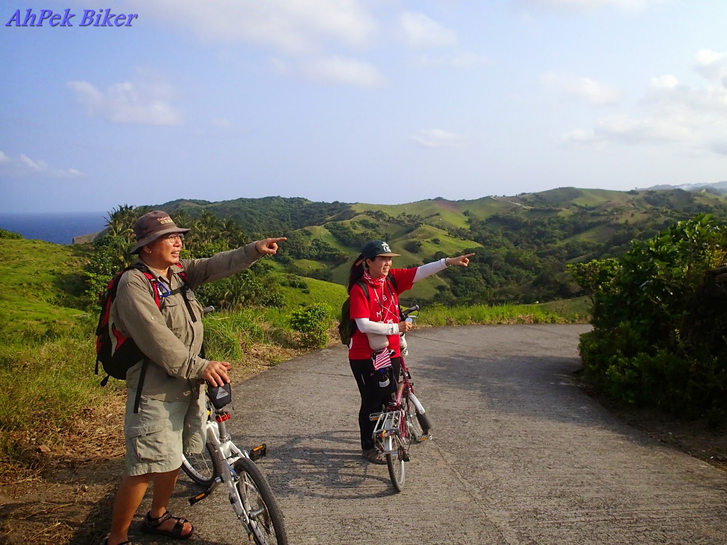 |
| My friends pointing the way to the Fundacion Pacita, it seems a distance away. |
Some locals informed us that the place was closed for renovations, so we decided not to ride over. But probably it was just an excuse for us; the hotel seemed a distance away and the road leading there seems treacherously steep - and we had had only a few hours sleep this morning.

Somewhere along the "whooshing", a strong gust of wind came and blew Ong's hat over to an open field and down a slope. We stopped and looked and looked but could not find it. Poor Ong, that loyal hat had been accompanying him on his travels for a long time and had served him well.

 |
| (Photo courtesy of Ong Kay Swee). |
 |
| (Photo by Siew Yung) |
The dark blue sea merging to a light blue horizon, the waves with slow staccato roars and a strong wind whispering in the air - the picture is just perfect.

These boulders were hot rocks spewed out onto the beach by Mount Iraya eons ago when it was an active volcano. The waves have through the ages slowly eroded them into the round boulders we see today.
___________________________________________________________________________________

Fortunately there was this ugly fellow, a coconut crab, to keep us occupied for a while; we were tempted to order this crab for part of our dinner, their pricing of almost 2,000PHP was an expensive deterrent. (On another day, we did get to savour this delicacy.)

"Hey, are those edible by humans?" I enquired.
Fortunately, she did not develop any stomach upset or come out with any weird orange spotty rashes. They were edible after all.

(that's Good Night in Filipino)
This is page 3 of a 13-page blog, Click Here To Go To Title Page.
___________________________________________________________________________________
Related Blogs :
 |
 |
 |
 |
 |
You May Also Like :  | ||||


 |
 |
 |
 |
 |
 |
 |
 |
 |
 |
 |
 |
 |
You are at - Jotaro's Blog / AhPek Biker / Cycling Philippines Batanes / Day 2-2 : North Batan Beauties | Jump to Day 1 / 2-1 / 3-1 / 3-2 / 4 / 5-1 / 5-2 / 6 / 7-1.1 / 7-1.2 / 7-2 / 8
(comments most welcomed below. if you like this pls share via facebook or twitter)